Wilayat Of Dhank ولاية ضنك

Wilayat Of Dhank


ولاية ضنك

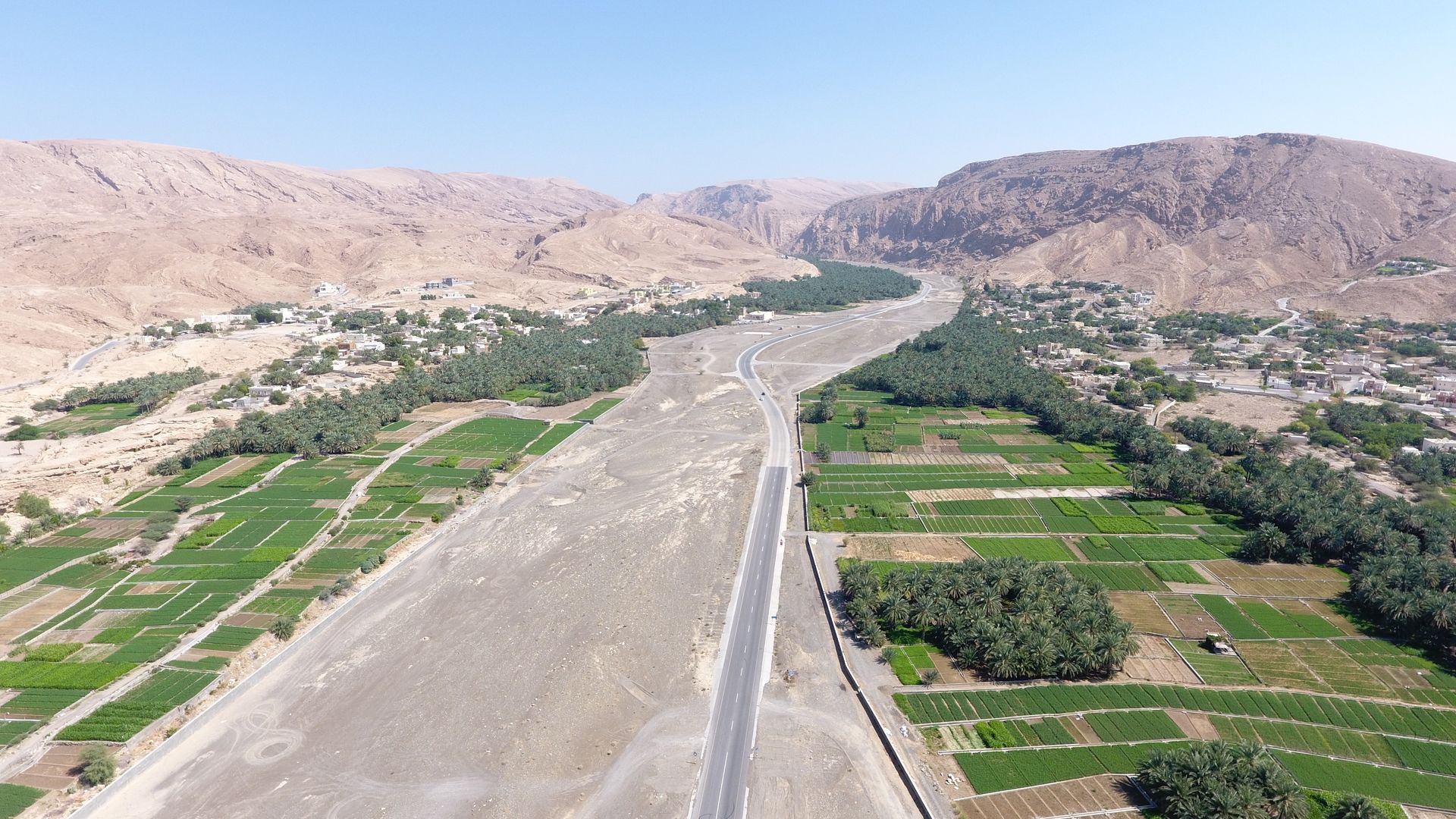
في سفوح الجبال الشاهقة تربض ضنك بحضارتها وتراثها تنام في السفوح قريرة العين ، ضنك هذه الولاية الواقعة تحت رصد الجبال تحتضن الطبيعة بقممها ووهادها وهضابها فجعلت الأكم أبراجا ومن الوهاد حصونا وفي الهضاب مسكنا وزرعا.

الطبيعة وجمالها في المنطقة آية من آيات القدرة الإلهية وسر من أسرار الإعجاز الرباني لما تمتع به ضنك من جمال الطبيعة مما جعلها منطقة جذب لكثير من الزوار ،ويقف الماضي على ضنك ينشد أنشودته الخالدة لتكون ماضي الأجداد تذكرة للأحفاد حيث الأطلال تحكي قصة الأوائل والأبراج والحصون تشرح للزائر عهدا وتعرض له مجدا تليدا .ضنك بجمالها الساحر تستوقفك مشاهد تأخذ الفكر وتستحكم العاطفة لتعايش طبيعة خلابة جميلة تزخر بها الولاية .موقعها تقع الولاية في وسط محافظة الظاهرة ، حيث تتصل بها ولاية السنينة من جهة الغرب ، وولاية عبري من جهة الجنوب، وولاية ينقل من جهة الشرق ، وولاية البريمي من جهة الشمال.

حظيت ولاية ضنك كسائر مدن وولايات السلطنة بفيض وفير من معطيات النهضة المباركة تحت ظل القيادة الحكيمة لمولانا حضرة صاحب الجلالة السلطان هيثم بن طارق المعظم ـ حفظه الله ورعاه ـ في قطاع التعليم والخدمات الصحية والبنية الأساسية.

وسميت ولاية ضنك بهذا الاسم لأن الجبال تحيط بها من كل جانب وتعرف أيضا باسم (العوياء) فهي متعرجة بطول مجرى الوادي ويعتبر وادي فدى من أشهر الأودية.

تقع ولاية ضنك في محافظة الظاهرة وهي إحدى ولايات المحافظة الثلاث، تحدها من الغرب ولاية السنية ومن الشمال ولاية عبري أما من جهة الشرق ولاية ينقل، حيث تقدر مساحة الولاية بحوالي 2030 كيلو متر مربع.

شعارها الأودية هي شريان حيوي يتدفق عبر شرايين سواقي وجداول كل الولاية يسقى مزارعها ويغذي أهاليها ويضفي إليها طبيعة ساحرة فريدة يجعلها روضة يتردد إليها السواح ويتمتعون بمنظر هذا الوادي وولاية ضنك اتخذت شعارها وادي فدى وهو شعار يسمو بالبيئة التي تتعدد بها. وصف المؤرخين ضنك : في ضنك ... تتعدد المعالم الطبيعية من قلاع وحصون وأفلاج وأودية ثروة صنعها الله لأصحاب الأرض ... وثروة أخرى صنعها الناس لأنفسهم فتضاعفت الكنوز.

يبلغ عدد القرى والمناطق التابعة للولاية حوالي (52 ) قرية وبلدة ،تتمثل في مركز الولاية :  ( المعذاء ، العلايه ، الوسطى ، العزيزي، سفالة الشكور ، الوحاشا ، أبو كربه  ، بلدة الطف ، بلدة دوت ، بلدة فدى ، بلدة الظويهرية ، بلدة قميراء ، بلدة بلت ، بلدة الجهمية ، وادي ضنك ).

المواقع الاثرية بالمحافظة 


قلعة عبري – قلعة السليف وحي السليف – حارة الرمل – حصن العينين – موقع بات الأثري – قلعة العراقي – القلعة السوداء – حصن بيت المراح – حي الشعبانية – بلدة الوقبة – قلعة المناخ – حي المرقوع – قلعة البزيلي – سوق السبيخة

قلعة عبري وقلعة السليف

تقع قلعة عبري في مركز المدينة، بجوار السوق القديم. يعود تاريخها إلى حوالي 400 عام، أنشأها بنو نبهان وأكمل بناءها الشيخ خاطر بن عامر بن راشد اليعقوبي. تضم القلعة عدة مداخل أشهرها: صباح السنسيلا، صباح الحصن (المدخل الرئيسي)، وصباح الوسطي (المستخدم للبرزات). وتحتوي على مسجد كبير لا تزال تقام فيه صلاة الجمعة وبقية الصلوات. تشتهر القلعة بنقوشها التاريخية وآثارها العتيقة، ومنها ثلاث أبراج: الصرم، الغُرابية، وصباح السنسيلا.

 قلعة السليف

فقد بُنيت في عهد دولة اليعاربة على يد الإمام سلطان بن سيف اليعربي عام 1718م، أي قبل 300 عام، عند سفح جبل شنبو المطل على وادي السليف. تحيط بها أسوار ضخمة وسبعة أبراج أشهرها برج الرياح. وتُعرف قرية السليف بوجود 110 منزلًا أثريًا، وسوق تراثي، وتصاميم معمارية عمانية أصيلة. تقع القرية على بعد 5 كم من مركز عبري، واشتهرت تاريخيًا بالنخيل والموارد الزراعية، وبموقعها الاستراتيجي المطل على الطرق الشرقية المؤدية إلى عبري، مما منحها أهمية دفاعية.

قرية الرمل

تُعد قرية الرمل موقعًا أثريًا يعود إلى أكثر من 300 عام، تقع في وسط عبري على منحدرات وجبال جبل الرمل.

حصن العينين

يقع على الطريق الرئيسي بين عبري والرستاق، وهو مثال جميل للعمارة العمانية التقليدية.

موقع بات الأثري

يقع في ولاية عبري بمحافظة الظاهرة، ويُعد موقعًا مدرجًا ضمن قائمة التراث العالمي لليونسكو، ويرجع تاريخه إلى الألف الثالث قبل الميلاد. يضم الموقع قبورًا بأسلوب أم النار في الجنوب، وقبورًا على شكل خلية نحل في الشمال، بالإضافة إلى ستة مبانٍ دائرية حجرية كبيرة، بعضها يحتوي على آبار مياه ومحاطة بخنادق مثل برج رجوم. تعود هذه المباني إلى عصر حفيت (3200–2700 ق.م)، وتضم معالم مثل برج الخاتم.

قلعة العراقي

تقع وسط بلدة العراقي، وتضم برجين وغرفًا ومستودعات وثلاثة آبار مياه. القلعة مستطيلة الشكل، مبنية من الحصى والطين والجبس و"السروچ". وتحتوي من الداخل على منازل قديمة وغرف خدم وقاعة ضيافة.

القلعة السوداء (حصن الأسود)

تقع في مقنيات، داد خصيب، على الحافة الشرقية لسهلٍ وادٍ، وبُنيت سنة 972 هـ (1564 م). تضم أربعة أبراج، وتقع على مرتفع صخري يتيح لها إطلالات استراتيجية على المناطق المحيطة.

حصن بيت المراح

يقع في قلب وادي ينقل بقرية الحصن، ويعود تاريخ بنائه إلى ما قبل الإسلام أو القرن 11 هجري (القرن 17 ميلادي). تحيط به مزارع النخيل، ويشتهر ببنائه الطيني والحجري التقليدي، وقد رممته وزارة التراث والسياحة عام 2002.

قرية الشعبانية

تعد من أكبر وأهم قرى ينقل، وتشتهر بمنازلها الطينية التقليدية المبنية بجذوع وسعف النخيل. تعرف بترابط سكانها الذين يتجمعون صباحًا لتناول القهوة العمانية.

بلدة الوقبة

تقع على بُعد 38 كم من مركز عبري، وهي بلدة جبلية ذات مناظر خلابة، تضم أودية مثل وادي بيح ووادي العريشي، مما يجعلها وجهة سياحية. وتتميز بالكهوف الجبلية، وموارد المياه، والمواقع التراثية، مع المحافظة على العمارة العمانية التقليدية.

قلعة المناخ

تقع في ولاية ضنك، وتبلغ مساحتها 1200 م²، وتضم ثلاث أبراج وعدة غرف ومستودعات. وقد رُممت بين عامي 2013 و2017، وتزوّدت بالخدمات الحديثة كالكهرباء والتكييف، مع تسهيلات لذوي الاحتياجات الخاصة.

قرية المرقوع

تقع في حي العزيزية بولاية ضنك، وتُعرف بأهميتها التاريخية والسياحية. تحدها عدة مناطق: الوسطى، العليا، المعزاء، الشكور، والوحشة.

قلعة البزيلي

تقع في قرية البزيلي بولاية ضنك، وشُيدت في عهد اليعاربة بالقرب من مجرى ماء يُعرف باسم فلج البزيلي، وهي من أبرز المعالم التاريخية المحفوظة في المنطقة.

سوق السبيخة

يُعد من أقدم الأسواق التراثية التقليدية في ولاية ضنك، واشتهر بنشاطه التجاري وسط بساتين المياه، ما جعله محط أنظار التجار من مختلف المناطق. ولا يزال السوق وجهة مفضلة للزوار والسكان المحليين.

الفنون التقليدية


الفنون التقليدية

تعكس الفنون الشعبية التقليدية، مثل الرقصات والأناشيد، في ولاياتنا الهوية الثقافية لمواطني سلطنة عُمان. وتُعد هذه الفنون تجسيدًا حيًا للعادات والتقاليد، لاسيما خلال الأعياد الدينية والوطنية، وحفلات الزفاف، والمناسبات الاجتماعية الأخرى. يشارك كل من الرجال والنساء في هذه الفعاليات، والتي تنتشر بشكل واسع في ولايات عبري، ينقل، ضنك، ومنطقة حمراء الدروع. ويمارس أهالي هذه المناطق فنونًا غنية بالإيقاع والشعر، حيث يُلقي الشعراء قصائد في المديح، والغزل، والوصف، والفخر في المناسبات الوطنية والاجتماعية.


تشمل الآلات الموسيقية والإيقاعية المستخدمة في فنون محافظة الظاهرة: طبول الكاسر، الرحماني، والواقف، وهي من أبرز الأدوات التقليدية في المنطقة.


فن العيالة

هو رقصة تقليدية تُؤدى على صفين متقابلين من الرجال. يقف أفراد كل صف متقاربين، ممسكين بأيدي بعضهم، ويحيطون خصور بعضهم بالأذرع الأخرى، في دلالة على التلاحم والتعاون القبلي. وتُعزف الموسيقى بين الصفين باستخدام آلات نحاسية مثل الطبول والدفوف. ويقود الإيقاع رجل يحمل طبلة أسطوانية ذات وجهين تُسمى "الكاسر"، تضفي على الرقصة إيقاعًا نشيطًا متناغمًا مع الشعر المُلقى.


فن الميدان

يُعد من أشهر الفنون الشعبية التقليدية في سلطنة عُمان، ويشترك في أدائه سكان محافظة الظاهرة ومحافظات أخرى. يقوم على تبادل الأشعار والحوار بالكلمات بأسلوبٍ فني نابض بالحيوية، ويؤدى غالبًا في المناسبات الاجتماعية مثل حفلات الزواج، أو للترفيه، وأحيانًا لأغراض العلاج الشعبي، خاصة لمن يُعتقد أنهم تحت تأثير الجن.


فن الونة

يُمارس هذا الفن عادةً في حلقات، حيث يجتمع الناس حول المؤدي الذي يضع راحتيه على وجنتيه ويغني بعينين مغمضتين، ثم يشاركه شخص آخر يردد البيت الأخير من النشيد بنفس الطريقة. ويتميز هذا الفن بجماله وتكراره المتناغم، ما يعكس انسجامًا عميقًا بين المغني ومرافقه.


فن التغريدة (التغرودة)

التغرودة فن بدوي يُرتبط بركوب الجمال، ويُؤدى غالبًا أثناء سير الجِمال في رحلات التَخَب (الهرولة). قديمًا، كانت تؤدى كأغنية سردية في المجالس البدوية الليلية، وتُعرف أيضًا بأسماء مثل "رزحة البدو" أو "رزفة البدو". يتم الغناء بنغمة ثابتة مع مدّ الحروف، دون استخدام آلات موسيقية، وتنتشر في مختلف المناطق البدوية في السلطنة بأسماء مختلفة مثل التغرودة، التغريد، الغيرود.


رزفة البدو

فن تقليدي بدوي يُمارس في مناسبات عديدة مثل الأعراس، الختان، عيد الأضحى، عيد الفطر، والمناسبات الاجتماعية الأخرى. يختص به الرجال، حيث يصطف المشاركون في صفين متقابلين. يُلقي شاعر القصيدة على أحد الصفين فيبدأ بالغناء، ويُردده الصف الآخر بالتوازي، في نمط غنائي متناسق. ويتحرك المؤدون بين الصفين حاملين العصي أو البنادق أو السيوف، ويقومون بحركات إيمائية مثل إيماء الرأس وثني الجذع، بل وقد يُلقون بالأسلحة في الهواء ثم يلتقطونها أو يدورون بها مكونين أشكالاً جمالية.


قلعة بيت المراح

تقع في قلب وادي ينقل بقرية الحصن على الجانب الشمالي الشرقي من جبل حورا، ويحدها من الجنوب جبل الخاتم. تختلف المصادر التاريخية حول تاريخ إنشائها؛ فبينما يرى البعض أنها تعود لما قبل الإسلام، يرجح آخرون أنها بُنيت في القرن 11 هـ (القرن 17 م)، بينما يشير مصدر ثالث إلى أن منشئها هو مخزوم بن فلاح النبهاني في أوائل عهد النباهنة. شُيّدت القلعة من الطين والحجر، وقد رُممت منذ عام 2002 باستخدام مواد تقليدية مثل السروچ.


قرية الشعبانية

من أكبر وأهم القرى في ينقل، وتضم بيوتًا أثرية قديمة مبنية من الطين وسعف النخيل، وأبوابها مصنوعة من خشب السدر. لا تزال القرية تمثل رمزًا للصمود العُماني، حيث صمدت منازلها أمام الأمطار وتعاقب الزمن. ويشتهر أهالي القرية بروحهم الجماعية، حيث يجتمعون صباحًا لتناول القهوة العمانية في طقس اجتماعي متوارث.


بلدة الوقبة

تبعد 38 كم عن عبري، وتُعد من أجمل بلدات محافظة الظاهرة، محاطة بجبال شاهقة من سلسلة الحجر الغربي. تشتهر بالنشاط السياحي، وتضم أودية مثل وادي بيح ووادي العريشي التي توفر بيئة مثالية للراحة والاستجمام. كما تحتوي على بيوت تراثية مبنية بالعمارة العمانية التقليدية، وكهوف جبلية، وعيون مياه صافية تجذب هواة التسلق والاستكشاف.


قلعة المناخ

تقع بولاية ضنك، وتغطي مساحة 1200 متر مربع. تتضمن ثلاث أبراج، وبوابة رئيسية تُعرف بـ "الصباح"، وقاعة اجتماعات، وغرف ومستودعات. وقد قامت وزارة التراث والثقافة بترميم القلعة بين عامي 2013 و2017، محافظة على طابعها الأصلي باستخدام الطين والسروچ والحجر، مع تزويدها بخدمات حديثة للزوار، بما في ذلك تسهيلات لذوي الاحتياجات الخاصة.


قرية المرقوع

تقع في حي العزيزية بولاية ضنك، وتتميز بأهميتها التاريخية والسياحية. تحدها عدة بلدات هي الوسطى، العليا، المعزاء، الشكور، والوحشة.


قلعة البزيلي

تقع في قرية البزيلي بولاية ضنك، وقد بُنيت في عهد دولة اليعاربة. يمر بالقرب منها مجرى ماء يُعرف بـ فلج البزيلي، ولا تزال القلعة محفوظة كأحد أهم المعالم التاريخية في المنطقة.


سوق السبيخة

يُعد من أقدم الأسواق التراثية التقليدية في محافظة الظاهرة، ويجمع بين الطابع التاريخي والنشاط التجاري. يقع السوق وسط بساتين وجداول مياه، مما يجعله وجهة مفضلة للتجار والزوار. يُعرض فيه مجموعة واسعة من السلع مثل التوابل، القهوة، المواشي، والأسماك المجففة. وقد شهد السوق تعافيًا اقتصاديًا منذ السبعينيات، بفضل موقعه الاستراتيجي بجوار القلعة التاريخية.

Wilayat Of Dhank

On the very top of high mountains, Dhank lies with its rich civilization and heritage, resting calmly in the foothills that embrace nature with its peaks, valleys, and plateaus.It turns mountain tops into towers, ravines into fortresses, and hills into a place of dwelling and agriculture.The beauty of nature in this region is nothing short of divine power and a secret of divine miracles.Dhank has flourished with nature's beauty, making it an attraction center for many visitors.
The past stands at Dhank and sings its immortal song, remembering the ancestors and guiding the next generations.The ruins tell the story of our ancestors while towers and fortresses demonstrate to visitors the majestic era, showing them a glorious past.Dhank's charming sceneries take your thoughts and manipulate your passion for coexistence around such beautiful nature found in the province.
Dhank is located in the middle of the Al-Dhahirah region, where it is connected by the province of Buraimi from the west, the province of Ibri from the south, the province of Yanqul from the east, and the province of Mahdah from the north.
The province of Dhank, like other cities and provinces of the Sultanate, has enjoyed an abundance of the prosperity of the blessed renaissance under the wise leadership of His Majesty Sultan Haitham bin Tariq, may God save and protect him, especially in education, health services, and infrastructure sector.
The province of Dhank is known for its name because the mountains surround it from all sides and it is also known as (Al-Awya), it winds along the course of the valley.Wadi “Fida” is considered one of the most famous valleys.
Dhank province is located inside the administrational borders of Al-Dhahirah Governorate.It is one of three provinces of the governorate, bordered to the west by the Sunnia province, to the north by the province of Ibri, and to the east by the province of Yanqul, where the area of the province is estimated at around 2030 square kilometers.
Its slogan is “The valleys are a vital artery that flows through the supply of precious waterways and streams all over the province, watering its farms, feeding its people, and giving it a unique charming nature that makes it a heavenly garden attracting tourists to enjoy the amazing view of this valley.The province of Dhank has taken “Wadi Fida” as its slogan, which transcends its abundant environment.Historians described Dhank as follows:“In Dhank, there are many natural and human-made landmarks like castles, fortresses, streams, and valleys.A gifted fortune from Allah for the land owners, and another wealth that people made for themselves multiplying the province with both natural and human-made treasures.
The number of villages and areas of the province is about (52) villages and towns, represented in the center of the province: Al-Ma'zaa, Al-Alayah, Al-Wusta, Al-Azizi, Al-Shakur, Al-Wahasha, Abu Karba, Al-Tuff town, Dot town, Fida town, Al-Zawihriyah town, Qamira town, Belt town, Jahmiyah town, Wadi Dhank. 

Archaeological sites


Archaeological sites


 Ibri Fort                  Al-Salif Castle and Al-Salif Neighborhood         Haret Al-Raml 

Hisn Al Ainain          The archaeological site of Bat                          Iraqi Fort 

Black Fortress            Beit al-Marah Fort                                        Shaabaniyah Quarter 

Al-Waqba town          Al Munikh Fort                                            Al-Marqoo’ Neighborhood  

Bazili Fort                  Sabikha Market

  •  
  • Ibri Fort
Al-Salif Castle and Haret
  • Ibri Fort is located in the center of Ibri, adjacent to its old market, where its construction dates back nearly 400 years.This invincible fort was established by Al-Nabahna, and its construction was completed by Sheikh “Khater bin Amer bin Rashid Al-Yaqoubi”.The fort has several entrances and gates, the most famous of which is “Sabah Al-Sensila” and another entrance called “Sabah Al-Hosn”, which is the main entrance to the fort, and “Sabah Al-Wasati”, which is used for Al-Barza.The fort has a large mosque in which Friday prayers and other prayers are still hosted.It is characterized by its historical inscriptions and ancient monuments, it has 3 towers: Al-Sarm, Al-Ghorabiya, and Sabah Al-Sensila Towers.
Castle and village of “Al-Salif”:
The castle was built in the era of the Ya'ariba’s state, and was constructed by Imam “Sultan bin Saif Al-Yarubi” in 1718 AD, 300 years ago, at the foot of Mount Shanboh, which overlooks Wadi Al-Salif.The fort is characterized by its huge wall, which surrounds it from all sides, and by its seven towers, the most famous of which is the wind tower.It is also distinguished by its ancient archaeological 110 houses, its archaeological market, and its decoration which reflects the arts of traditional Omani architecture.
The town of Al-Salif is 5 kilometers away from the center of Ibri.It is a city full of historical and natural elements and resources.It has enjoyed many achievements that added to its beauty and elegance.The town of Al-Salif has been famous since ancient times for palm trees and various agricultural crops.The Village of Al Salif is located on the southern edge of the oasis's eastern corridor, on top of a cliff of a prominent slope that gives it a magnificent view overlooking the eastern roads.The village seems to have initially come to life as a defensive stronghold position, controlling the passage leading to Ibri from the east.
Al-Salif village witnesses many changes in its population from season to season, because in the date harvest season, most of the residents live in palm groves and agricultural lands, and they do not return to their village homes until after the harvesting process is completed.The village was built at the foot of Mount Shanboh overlooking Wadi Al-Salif, during the reign of Al-Yarubi Imam, "Sultan bin Saif II" (1123-1131 AH / 1711-1718-19 AD).Given the importance of this position as an exit way to the Oasis of Ibri, it is plausible that a watchtower or defensive base can be found before the fort on the hill overlooking the valley (both of which were known as Shanboh).
  •  Raml Village: 
Raml village is one of the archaeological villages, built more than 300 years ago in the center of Ibri on the slopes and hills of Al-Raml Mount.
  •  Al Ainain Fort:
Al Ainain Fort is located along the main road between Ibri and Rustaq to the north of Ibri. It resembles the beauty and splendor of Omani architecture. 
  • Bat Archaeological Site
The historical sites are located in Bat, Al-Khatam, and Al-Ain in the governorate of Al-Dhahira, Ibri Province, and are considered archaeological and historical sites dating back to the third century BC and located to the east of Ibri.It is ranked only the second World Heritage site to be added to the World Heritage List in Oman in 1988.The site includes the tombs of the um al-Nar style in the southern part, and the graves of beehives in the northern part dating back to the third millennium BC, which resembles in their construction type the burial chambers of the “Hafeet” period.There is also a cemetery that was unearthed that contained 100 tombs built of stones and reflects the development in their construction manner from the burials of beehives to the burials of the um al-Nar period, as the beehive burial site includes between 2 to 5 burials.
The site of Bat contains 6 huge circular-shaped stone buildings distributed at the site and in the village of Bat, most of which possess a water well in the middle, and a number of them have been surrounded by a trench such as Al-Rajum tower.Mud-built rooms on stone foundations were attached to all these buildings.The buildings were built in different eras, the oldest of which dates back to the Hafeet era (3200-2700 BC), such as the Al-Khatm Tower and the Khafa Tower.
The Bat site contains 6 huge circular stone buildings distributed throughout the site and in the village of Bat. Most of them have a water well in the middle. A number of them were surrounded by a moat, such as the Rajum Tower and Tower (1156). To all of these buildings were attached rooms built of mud on stone foundations. These buildings were built in different periods, the oldest of which dates back to the Hafeet era (3200-2700 BC), such as Burj al-Khatm and Burj al-Khafa.
  •  Al Iraqi Fort
Al-Iraqi Fort is located in the center of the Iraqi town, and it has two towers: the plaster and the clay towers, and there are several rooms and stores, and three water wells.The fort is rectangular in shape, consisting of two floors.Gravel, clay, plaster, and sarooj were used in its construction.Inside the fort, there are ancient houses with service rooms, and a hospitality hall.Such houses have a special door to the east called (Al-Rawia) door which typically leads to the adjacent stream.
  • Al-Aswad Fort:
This fort is located in “Maqniyat” of “Dad Khasib” on the eastern edge of one of the valley plains, just between the folds of the mountains.It dates back to the year 972 AH and is a high invincible fort that includes four towers: the wind tower, the control and landfills tower, the morning tower, and the tower of Solomon.The entire area was dominated by this Fort, which is located on a high rocky outcrop with palm groves spreading along its slopes.There is a well-defined winding road (fenced in some areas) that leads to the terrace facing the arched entrance near the western tower, while on the northeastern side of the terrace, there is a vertical slope that reaches to the very low ground level, which makes the only road leading to the only entrance very narrow and difficult to attack or breach.
  • Bait Al Marah Fort
It is located in the heart of Wadi Yanqul in Al-Hosn village on the northeastern side of Mount “Hura” bordered to the south by Mount “Khatim”. Historical sources argued a lot about the date of its construction, one of which mentions that it was built before Islam, a second source suggests that it was built in the eleventh century AH (seventeenth century AD), while a third source says that it was built by “Makhzoum bin Falah Al-Nabhani” at the beginning of the era of the Nabahna in Amman. The fort was built with mud and stones, and the Ministry of Heritage and Culture began its restoration and rehabilitation works in 2002 using Sarooj material.
Surrounded by palm plantations, the fort is close to the remnants of an abandoned village and dates back to the seventeenth century. The walls of the fort are surrounded by a large series of buildings, among them a mosque built in the traditional style.
  • Al-Shaabania Village:
This village is one of the largest and the most important villages in the province of Yanqul, as it hosts the largest number of people at the time. This village consists of old archaeological houses inhabited by the people and has been used until recently. Father “Hamid” says that the old neighborhood houses were built with mud with palm fronds and trunks, and even the doors were manually crafted by Omanis using Sidr tree until recent years, and they persisted through all these years, as the houses remained resistant to rain and survived the age. Back in time, people used to meet each other in the morning to share Omani coffee, which has been a well-established habit since ancient times. The advantage of living in a village is that it brings everyone together as if they were one family, despite the overlap of houses with each other but it did not stand in the way of the people's cooperation in the village, which is an advantage of the Omani village’s lifestyle.
  •   Waqba town
The town of “Al-Waqba" in the province of Yanqul within the governorate of Al-Dhahira is considered one of the most beautiful towns and villages in the entire province due to its attractive tourist potential. The town is located nearly (38) kilometers from the center of the province, between several towering mountains within the Western “Hajar” mountain range. It is mountainous in nature, as it connects Al-Dhahirah Governorate with several other governorates besides Sohar Industrial Port, as well as several provinces, villages and regions.
The town of “Al-Waqba" is one of the beautiful touristic attraction sites, as there are several valleys that witness an active tourist movement, especially with the valley flow, as it offers cozy and comfortable places for rest and recreation, such as Wadi Biha and Wadi Al-Arashi. Mountain caves spread within the mountain tops attracting many hiking and climbing lovers, in addition to the presence of clear water sources that form right after the flow of valleys. The town of “Al-Waqba" is also characterized by the presence of many heritage sites and cultural landmarks such as ancient houses, which are still standing tall today with their splendor and the ingenuity of their beautiful Omani-style architecture.
The “town of Al-Waqba” is one of the beautiful tourist stations, as it has a number of valleys that witness an active tourist movement, especially with its flow, as it constitutes a suitable place for rest and recreation, such as Wadi Biha and Wadi Al-Arshi. Mountain caves are also spread on the mountain peaks, which attract many climbing lovers in addition to To the presence of clear water sources that are formed after the flow of the valleys. "Al-Waqba Town" is also distinguished by the presence of many heritage sites and cultural landmarks, such as old houses, which still stand tall today with their splendor and the ingenuity of their beautiful Omani engineering.
  •  Munaikh Fort
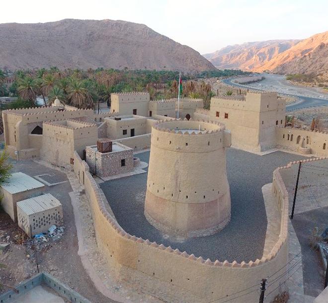
Al-Muneikh Fort is considered one of the heritage sites in the province of Dhank, where the length of the fort is (40) meters, and its width ranges between (30-35) meters, with a total area of (1200) square meters.
The fort consists of three towers, its main gate called “Sabah”, a general assembly hall, a group of rooms and stores, as well as visitor parking lots and lots of beautiful landscapes surrounding the fort. The Ministry of Heritage and Culture, represented by the Restoration and Conservation Department of the General Directorate of Antiquities and Museums, has completed the restoration of Al-Munikh Fort in Dhank province in Al-Dhahirah Governorate. The restoration started in August 2013, and it was carried out in several stages, such as the stages of documentation, photography, cleaning and consolidation work, and then the preparation of detailed drawings for the restoration work, taking into account the preservation of the original building and architect style in which the fort was built while using traditional building materials such as clay, sarooj and stones. The fort was provided with all the necessary services such as electricity, air conditioning systems, and toilet facilities. For the first time, people with special needs will be able to visit the fort, as their related requirements were taken into account during the design phase of restoration activities.
  •  Al-Marqua Village:
Al-Marqua village is located in the Al-Azizi neighborhood in Dhank province within Al-Dhahirah Governorate and is characterized by many aspects of historical and touristic diversity, as Al-Marqua Village is located in the middle between its neighboring towns. It is bordered to the east by the towns of Al-Wusta and Al-Alaya, to the north by the town of Al-Ma'zaa, to the south by Al-Shakur and Al-Wahsha, and the west by the fortress of the late Sheikh “Matar bin Salem Al-Azizi”. 
  •  Bazili Fort
It is located to the west of Dhank within the governorate of Al-Dhahira at a distance of about 35 km. This fort was built in the era of Ya'ariba and its remnants still exist to this very day. The Bazili Fort is one of the ancient historical monuments of the province of Dhank, which is located in the village of Al-Bazili. A water stream is present on site, which is called “Falj Al-Bazili” and it was built during the state of Ya'ariba’s era.
  • Sabikha Market
The old "Subeikha" market in the province of Dhank within the governorate of Al-Dhahira is one of the ancient traditional heritage markets and one of the oldest markets in the whole province, where it combines originality with ancient heritage. It is also considered a large multifaceted historical heritage full of past commercial movement and surrounded by towering orchards and streams, attracting people from all near and far provinces and regions carrying whatever goods they have for sale among livestock, and summer and winter products, benefitting from its unique location next to the historical fort.
It was named Al-Subeikha Market based on the fort and was the center of attention of both traders and buyers. It is overwhelmed with many local goods and multiple products such as spices, legumes, coffee, fabrics, blacksmithing, selling livestock, fodder, ghee, honey, dates, lemon, dried fish, and fresh meat. The market has been a destination for many visitors from various regions of the Sultanate during the past years, and it has been witnessing a steady recovery economically and commercially since the seventies because of its many advantages, including its distinguished geographical location.